Delaware Map
|
 |
 |
Where Is Delaware?
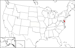
Delaware's location is shown in red on the map to the right. The State of Delaware is bounded by Pennsylvania on the north, and by the Delaware Bay and the Atlantic Ocean on the east. It is bounded by New Jersey on the northeast, and by Maryland on the southwest.
Delaware Maps
Delaware is the 49th largest state in the United States, covering a land area of 1,954 square miles (5,061 square kilometers). Wilmington and Newark, the state's largest cities, are clustered in the northernmost of Delaware's three counties. This Delaware map site features road maps, topographical maps, and relief maps of Delaware. The detailed, scrollable road map displays Delaware counties, cities, and towns as well as Interstate, U.S., and Delaware state highways. The pannable, scalable Delaware street map can be zoomed in to show local streets and detailed imagery.
Delaware Highway Map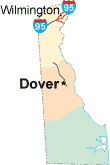 Click on the highway map thumbnail
to view a scalable Delaware road map. |
DE Topo Map Click map to enlarge.
|
DE Relief Map Click map to enlarge.
|
The detailed Delaware map and the regional Delaware map display cities, roads, rivers, and lakes as well as terrain features. The detailed map shows only the State of Delaware, while the regional map shows Delaware and the surrounding region.
Delaware Infrastructure > Delaware Airports
In 2005, the population of Delaware was estimated at 841,741, which is about 431.8 people per square mile. In 2010, Delaware's population rose to 897,934 people. More recently, in the 2020 census, the Delaware population was 989,948. The state's Interstate Highways include I-95, I-295, and I-495. Delaware has no major airports, but the New Castle Airport and the Delaware Airpark serve both corporate and recreational flyers.
Delaware Topography and Tourist Attractions
Delaware is named after the Delaware River and Bay, which themselves were named after Sir Thomas West, the Baron De La Warr. Delaware is the second smallest state (after Rhode Island). Most of the state lies on the DelMarVa peninsula, a coastal plain lying between Chesapeake Bay to the west and the Atlantic Ocean to the east. Tidal marshes teeming with wildlife along Delaware Bay gradually yield to sandy beaches along the southern shoreline. Rehoboth Beach and Bethany Beach are popular summer vacation destinations. For Delaware travel and tourism information, visit the official Delaware tourism site and Delaware Atlas.
Other Delaware Maps
This online Delaware reference map shows major cities, roads, railroads, and physical features in Delaware.Several map publishing companies offer printed maps of Delaware. For example, Omni Resources offers several maps of Delaware that feature points of interest, airports, and parks, as well as selected local attractions and insets of major Delaware cities.
All rights reserved.
Certain maps hereon are © Map Resources or Digital Wisdom.
To facilitate browsing, certain external links will open in new windows.
Delaware-Map.org Editor, State Maps, PO Box 828, Barnegat, NJ 08005.